Search Results
22 results found with an empty search
- A Coastal Walk - Chouet Bay to Cobo Bay, Guernsey, Channel Islands
‘Seeing the watery part of the world is a way I have of driving off the spleen and regulating the circulation. Whenever I find myself growing dim about the mouth; whenever it is a damp drizzly November in my soul; whenever I find myself involuntarily pausing before coffin warehouses....... I account it high time to get to sea as soon as I can’ Moby Dick, Herman Melville I have spent a lot of time walking the hills and valleys of Yorkshire, there is so much beautiful countryside, wide open moors with a rugged wildness that I love. However, I also love a good coastal walk, and I had the opportunity to try a new path this summer whilst visiting the stunning Channel Islands. The coastal walk from Chouet Bay to Cobo Bay offers fabulous views of the Guernsey coastline and this pristine part of the English Channel and this is path I took. It was a slightly grey July day and whilst the sun was not shining the walk was still beautiful; sandy beaches embraced by rugged rocks, a winding coastline and colourful boats. Chouet & Ladies Bay, my starting point, is a beautiful beach and headland on the northwestern coast of Guernsey. A sweeping sandy beach framed by rocky outcrops and a backdrop of greenery and gorse, which is in fact the second fairway on the Royal Guernsey golf course. Approaching Les Amarreurs the view is punctuated with pops of colour from upturned boats and kayaks on the beach and small boats, moored, bobbing gently on the calm sea. The path is clear and easy to follow which allows you to relax, enjoy the walk and take in the views. A coastal hike is so different to the senses from inland walks; the sounds, the smells, the wildlife and the scenery, the raw beauty of nature where land meets the sea. Looking out to the ocean it is easy to be both invigorated and soothed by the waves and the scattering light across the wide expanse of water. Facing the sea, I turned left and set off along the sandy path, fringed with windswept untamed grass towards my destination. Continuing along the path through the grassy headlands and low-lying dunes the coastline soon evolves and the sweeping pebble strewn sands of La Grand Havre open up offering a view of one of Guernsey’s largest natural harbours. A large shallow bay of serene, unspoiled beauty, this expansive bay offers a unique coastal landscape that contrasts with the island’s more dramatic, rocky shores. Grande Havre is rich in aquatic life and wildlife, especially bird-life. Wading birds like little egrets, oyster-catchers, and curlews frequent the fertile tidal flats and rock pools feeding on the abundance of shellfish and crustaceans and the remains of an Oyster farm can be seen out in the bay. A lone fisherman clad in a bright red jacket stood on the tide line adding an interesting centre point to the view. One of the joys of this walk is the diversity of the natural environment. The coastal paths are lined with windswept grasses and hardy wildflowers, adding splashes of colour to the landscape and the scent of wild fennel seems to be ever-present on this part of the coast. In addition to this abundance of natural beauty, the journey along leads to numerous historical landmarks. The island is area steeped in military history and the next bay and headland along this walk is Rousse. Rousse is a small headland that extends out into the sea, allowing for panoramic views across the north coast of Guernsey and out to the island of Alderney. The focal point of the peninsula is Rousse Tower, a tower and battery in a single fortification. Built in the late 18th century, the tower was part of the island’s coastal defences against the threat of French invasion during the Napoleonic Wars. Standing tall on the headland, this stone structure offers a glimpse into Guernsey’s military history. The walk up the path to the historical tower offers a fabulous view across the coastline and the surrounding seas. My walk continued along the winding path filled with rocky outcrops, sandy dunes with the sea as a constant companion. Scattered all along the coastline are further remnants of WW2 fortifications. These historic bunkers and gun emplacements are a stark reminder of war-time Guernsey. Many are now weathered and have been partly reclaimed by the wild natural landscape. The coastal path led me past the rocky bay and outcrop that is Portiner to the horse-shoe shaped bay of Port Soif, a small but perfectly formed and sheltered soft sandy beach. Tearing myself away from this lovely spot I continued along the path towards Grandes Rocques another scenic coastal spot. Grandes Rocques has a lovely stretch of soft white sand, fringed with distinctive, large granite rocks that jut out into the sea, backed by grassy dunes. The pretty beach cafe located there is a perfect stop off with its lovely colourful painted benches and a coffee with a beautiful sea view. The final stretch of my walk led me to Cobo Bay, one of the most striking and popular beaches on the island. Cobo has a wide expanse of soft, white sand and its stunningly clear waters making it a perfect spot for swimming and soaking up the sun. Cobo Bay also has a number of charming seaside cafes, pubs and restaurants, perfect for a post-walk refreshment. This linear coastal walk from Chouet Bay to Cobo Bay is an easy but wonderful coastal walk. It offers a perfect combination of rugged natural beauty, tranquil beaches, and fascinating history. While I did not get blue skies on the day of my walk, it was still beautiful, and I was happy to retrace my steps along this scenic path to where I started. Walked July 2024 🥾
- Blackpool Bridge Walk, Holme, West Yorkshire, UK
“Leave the road, take the trails .” – Pythagoras Some walks are special because of their familiarity, a well-known, much-loved walk that doesn’t require any map reading/or reaching for a printed sheet of directions. A walk where you already know the best picnic stop and the best view. Blackpool Bridge, Holmfirth, West Yorkshire is such a walk for me. It is a walk I have done many times over the years in all types of weather, and I never tire of it. The route can start at various points, but I have a favourite route I take each time I do this lovely 5/6 mile circular walk. Starting in the village of Holme on the outskirts of the famous ‘Last of the Summer Wine’ town of Holmfirth you cannot help but be charmed by this charming, picturesque village nestled in the Holme Valley and just within the boundary of the Peak District National Park. The village is ‘holme’ to a delightful village school and a fabulous country pub – The Fleece. It is a warm, welcoming village full of country traditions and community spirit. The walk, for me, starts on a public footpath on Meal Hill just below the village school, a grassy path leading onto a wide-open field. Walking the gentle descent across the field, the view opens out through the trees giving you a glimpse of Digley Reservoir, a stunning blue water, reflecting the sky above and surrounded by rolling hills and lush trees. The well-trodden path is easy to navigate with strategically placed benches, perfectly positioned to offer panoramic views of the water and surrounding countryside and a good picnic spot if you are doing the short reservoir walk. Continuing the walk, you come to a charming stone bridge that crosses a narrow babbling stream feeding into the reservoir. The bridge, old and moss covered, adds a rustic charm to the view as the water meanders over the rocks sparkling as it catches the sunlight. The first section of the walk is gently undulating, leading you through open meadows and woodland as you walk the path towards the waters of the reservoir. The path reaches the dam that crosses between Digley and Bilberry Reservoir and doubly rewards you with beautiful, far-reaching views from both sides across the reservoirs. Stop to saviour these views of the reservoirs, the wide blue waters surrounded by the sweeping hills of the Holme Valley and the rich greenery of the trees and bushes, leaning down to touch the waters edge. As you leave the dam the path leads gently uphill away from the open view of the reservoir through a lush, leafy section towards a bench set high on the left, a seat with a view. At this point, the path does continue around the edge of the reservoir for a short but scenic and varied circular walk of about 45 minutes but we took a left turn just after the bench for a longer walk up over the rolling hills and across the moorland on the edge of the peak district. The wide path climbs slowly upwards, following the drystone wall synonymous with this area of Yorkshire. As you climb upwards along this tranquil path it starts to feel like a country walk of lovely quietness with nothing but sheep and birdsong for company. Eventually you come across a sty taking the walk over the wall and down to Blackpool Bridge. Once over the sty the views are spectacular; heather capped rolling hills lead downwards towards the bridge and climb back up again in the distance as the winding path cuts through the outlying view, a wonderful invitation to keep walking. We made our way down the stunning valley as Blackpool Bridge came into view, a picturesque wooden bridge across the flowing waters of Marsden Clough beck. Legend has it that the name Blackpool Bridge comes from the black pools below the bridge that once upon a time local people used to swim in. It is now a beautiful picnic and paddle location as heather covered banks tumble steeply to the babbling river surrounded by gritstone rocks. A few larger rocks offer the perfect picnic seating with a view across the sparkling beck and up the heather filled valley. The original Blackpool Bridge was a grander stone structure and remnants of it remain today across the far side of the beck. Walking across the wooden bridge stop to take in the view upstream as the stunning, colourful rolling hills sweep down to meet the water. Once over the bridge the path climbs steeply uphill, across the stunning moorland, rich in colour and varied terrain. The path climbs, twists and meanders up and across the landscape and it is impossible not to be in awe of the breathtaking views and the feeling of beautiful wild isolation. Taking the ascent slowly and across the moorland, crossing rocky streams along the way the walk is a constant reminder of the gloriousness of nature and the open countryside. At the peak of the walk the view sweeps down the valley with the lush flora and fauna, the patchwork of stone walled fields and the blue waters of the tree lined reservoir nestled amongst this vista. Tearing ourselves away from this beautiful view we continued along the path leading away from the open moorland back towards Holme Village. The walk ends at the top of the village and gives you a chance to stop at the gates of the village school. A fabulous, charming village school that at capacity has around 35 pupils aged 5 to 11. My daughter was lucky to be a pupil at this school from 2002 to 2008 and she still has a presence there as part of the artwork on the school gate! Make sure you take time after this walk to visit the fabulous Fleece Inn; a gorgeous traditional country inn serving delicious food. It is a perfect end to this stunning walk, to spend time in the village having a well-earned meal and drink and time to reflect on the walk. A walk of wonderful, natural beauty, a walk of babbling rivers, sweeping hills, historical charm and beautiful wild landscapes – a perfect escape into the countryside. Walked and photographed many times in all seasons 🥾
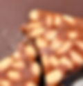
- Irresistible Butterscotch Nut-Brittle WARNING – one piece will not be enough!!
We first had this home-made nut brittle at a house party in New Zealand earlier this year. The host had made some and it became the topic of conversation at the party it was so good! We came home from the party armed with a good chunk of the nut-brittle (which we polished off that night) and the recipe. We have made this fabulous nut brittle many, many times since, while in New Zealand and back in Yorkshire. Each batch we make gives a slightly different result, but it is always delicious and very quick to make. I don’t think the country we make it in creates any variations it is equally good in both Hemispheres. Our party host made the brittle with Macadamia nuts, but we have been making it with salted peanuts and I am sure it would work with any nut of choice. Once made, we keep ours in the fridge then break some off whenever we fancy, perfect with a cup of tea. Look away now, if you want to resist this sweet treat, but if you want to go for it, here is the recipe below: Ingredients 100g Butter 200g Brown sugar Level teaspoon of salt Teaspoon of brown or white vinegar 5ml water Nuts of choice 150g of 80% cocoa chocolate Equipment Non-stick tin 11” x 7” (approx.) Parchment paper Method Line or grease the tin. Cover the base of the tin with nuts – be sure to break large nuts into small pieces – peanuts can be left whole. In a small saucepan melt the butter then add the vinegar, salt then the sugar and simmer until the sugar mix reaches 142 degrees. (this is important as its the crack-point for sugar). Pour the mix over the nuts and spread evenly and allow to cool. Break up the chocolate and melt by user the double boiler method (see below) then spread the melted chocolate over the top of the brittle and place in the fridge to cool. Double boiler method Simply bring an inch or two of water to a simmer in a pan, then place the bowl with the chocolate inside over the top, you need it to fit snugly without touching the water the chocolate will melt to a silky-smooth texture. Eat Once the brittle is cool and set, how you choose to eat it is up to you...... break it up using a toffee hammer and have a chunk whenever you pass the fridge........ break it into smaller pieces and sprinkle it over some vanilla ice-cream ........ take it to a house party – your hosts will love you!
- Is Golf A Good Walk Spoiled?
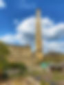
Featuring Crosland Health Golf Club, Huddersfield, UK and Whangaroa Golf Club, Northland, New Zealand ‘Golf is a good walk spoiled’ As a passionate hiker for many years, I have imagined this quote to be true. However, this year, for the first time, I was given the opportunity to challenge this view. I picked up a golf club for the first time and tried my hand at golf. Truthfully, it was not the very first time; there has been a few crazy golf sessions, pitch n putt on childhood holidays and a memorable ‘hole in one’ at an adventure golf course. I was, however, told not to mention the ‘hole in one’ at the golf club! So, at 58 there I was, a new member of a golf club in New Zealand, a new country for me and a new hobby, lots of ‘new’. Six months later and I have ‘played’ golf as a member at Whangaroa Golf Club in Northland, New Zealand and more recently at Crosland Health Golf Club in West Yorkshire, UK. First, a look at the golf courses......... Both golf courses encapsulate stunning features native to their respective location and are as different as they are similar. As my first experience on a golf course, Whangaroa Golf Club and its members did so much to dissolve my pre-conceived view of traditional golf clubs. It is such a friendly, relaxed country club where everyone warmly welcomes visitors and new members. Tucked away in the serene and scenic Northland region of New Zealand, Whangaroa Golf Club is located near the picturesque Whangaroa Harbour and is surrounded by the stunning natural landscape characteristic of this area. The club’s location provides panoramic views of lush green hills, vibrant flora, encircled by mature, native, and exotic trees, creating a beautiful environment. The walk around the 18 holes is stunning, nestled in a lush, rolling landscape, the golf course stretches across undulating hills that rise and fall gently. The course is surrounded by dense clusters of mature trees, including; Manuka, Pohutukawa and Totara all adding to the scenic terrain while giving an ever-changing experience as the seasons change. Between the fairways lie the roughs, covered in longer, more natural grasses. These areas are dotted with wildflowers and smaller shrubs, providing a contrast to the manicured fairways and greens and creative landscaped areas alongside the pathways. The course is designed to create challenges for the players which, in turn, adds to the beauty of the walk; passing over the charming, winding creek at hole 5 and reaching the tee boxes of holes 13 and 14 where the views across the landscape are far-reaching and stunning, the perimeter of the course here is lined with vibrant canna lilies adding to the glorious view. As you walk the course you are accompanied by the wonderful New Zealand wildlife. Wild turkeys cross the fairways, the distinctive call of the tui can be heard, small energetic fantails flit and follow you around the course and the striking colours of the rosella are a common sight. I walked the course and played golf here during the New Zealand summer months, and the start of autumn. The wide blue skies contrasted with the rich greenness of the landscape and the course was equally beautiful in the early morning sunshine or as the sun was going down at the end of a warm dry day. As the summer months gave way to autumn the early mornings would be shrouded in a light mist before giving way to more lovely sunshine. Whangaroa Golf Course is the perfect course for an introduction to golf for a keen walker like me; picturesque, lush rolling hills, far-reaching stunning views with a kaleidoscope of colours and textures, and a rich, varied landscape. Returning to the clubhouse at the end of 18 holes, there is always a warm welcome and a lovely, relaxed atmosphere to enjoy a drink and some light hearted golf talk with the other club members who quickly made me feel part of this community. Returning to West Yorkshire in May, it felt important to carry on my golf journey and, after looking at a few local to my hometown of Holmfirth, we found the perfect course. Crosland Health Golf Club is on the outskirts of the industrial town of Huddersfield, West Yorkshire. Built on what was once an unused quarry and farmland, the wide stretch of rolling terrain is full of natural beauty and again a course that artfully changes along with the seasons. The course has everything I love about the countryside of West Yorkshire, a countryside that is wild and resilient. While the fairway and greens are meticulously maintained, manicured and smooth, the surrounding landscape contrasts beautifully, with a wildness characteristic of the Yorkshire Moors, rugged heather covered banks tumble down into deep ravines, seeded grass and dense shrubs create the rough and weathered stone, remnants of the quarry, nestle amongst the rich shrubbery and natural greenery of the landscape, a historical reminder of a bygone industry. Wooden steps are built into the undulating terrain of the course and winding paths direct the players to each hole as the course meanders around the natural slopes following the natural contours of the landscape. The course is one of the highest in the country and offers truly spectacular, panoramic views taking in distant rolling hills, woodland areas and far-reaching views across Huddersfield town and beyond from North to South. Looking across from the tee-box at hole 10, two iconic Huddersfield landmarks, Castle Hill and Emley Moor mast stand tall, appearing to the eye to be side by side against the skyline. Stand out holes give the course areas of beauty and interest; in summer, the picturesque pond at the green on hole 10 is covered with vibrant pink water lilies floating along the top, the quarry holes of 9 and 17 are as stunning and dramatic to the eye as they are challenging to the golfer. Walking across the course it is clearly a gem of a club in the heart of West Yorkshire, a course that is designed in harmony with its rugged, natural, wild landscape. Its heathland setting, with rolling fairways, panoramic views, and dramatic deep quarry ravines, offers a fabulous country walk even for a non-golfer and public footpaths wind through the course. I walked and played this course in the UK summer months, which were a dramatic contrast to the New Zealand summer I had just experienced! The natural wildness of this course was regularly intensified with grey, moody skies and rolling clouds. The poor summer weather; cloud, wind, drizzle and threats of bigger downpours did not always show the course at its natural best, but its beauty and potential for gloriousness was clear to see. We were, however, rewarded on some of our early morning starts with lovely sunshine and the course was just beautiful. Hole 18 leads the player back down fairway towards the clubhouse. A fabulous relaxing clubhouse, with seating outside giving views of the first and last holes and again, as in New Zealand the welcome is warm and friendly and one of the reasons we chose to join this club for our summers in Yorkshire. Two golf clubs, two hemispheres, two summers and 6 months of golf ...... I am still passionate about hiking; a distant hill and a winding path give me joy, reaching the top of a hill after a challenging, strenuous climb gives me even greater joy and I doubt I will ever loose that feeling. Putting one foot in front of the other and walking for pleasure, without a golf trolly, will always be my ‘sport’ of choice. However, and I am surprised at this, I am starting to get golf. It is frustrating, difficult, and unnatural; I am consistently bad to varying degrees and always inconsistent in my game. Both courses have challenges I have yet to meet and overcome – the creek at Whangaroa and the quarries at Crosland Health, my golf balls still nestle there, buried deep, still waiting to be retrieved. When my drive is unexpectedly ok, my putting is spectacularly bad and vice versa and I long for the day when I par a hole. However, after each disastrous hole I look forward to starting again on the next hole and small wins on the course spur me on to do better. A good walk without pushing a golf trolley will always be a good walk to me, but, I am starting to embrace the 'walk' across a beautiful golf course, the peaceful, early morning tee-offs, the physical and mental challenge of the sport and the joy when the ball occasionally lands in the perfect spot. If you have been inspired and want to visit either of these fabulous golf courses, their websites are below: www.croslandheath.co.uk www.whangaroagolf.co.nz
- Saltaire to Bingley Five Rise Locks Canal Walk with a visit to Salts Mill
‘Adopt the pace of nature, her secret is patience’ Ralph Waldo Emerson We are back from New Zealand, spending the summer in West Yorkshire and while we have not seen much summer sunshine yet, the beautiful Yorkshire countryside is still here in all its glory. On a mid-June morning, we set off on one of the most picturesque and serene canal walks tucked away in the heart of West Yorkshire. Stretching from the historic village of Saltaire to the awe-inspiring Bingley 5-Rise Locks, this canal walk offers a wonderful blend of natural beauty, industrial heritage, and the leisurely leisure activity of canal life. The Victorian model of Saltaire, is a fabulous place to start. This UNESCO World Heritage Site, renowned for its rich history and stunning architecture was founded in 1851 by Sir Titus Salt, a model village built to house the workers of Salt's textile mill. Today, Saltaire retains much of its Victorian character and charm, with cobbled streets, quaint houses, and the imposing Salts Mill, now home to art galleries, shops, and cafes. Saltaire became a UNESCO World Heritage site in 2021 when they noted “Saltaire is an outstanding and well preserved example of a mid 19th century industrial town..... The layout and architecture of Saltaire admirably reflect mid 19th century philanthropic paternalism, as well as the important role played by the textile industry in economic and social development’ Before we set off on along the towpath we took some time to visit Salts Mill a stunning huge historical building, set over four floors and home to one of the largest collections of David Hockney’s art. A beautiful hub for arts and culture, the mill also has some lovely independent retail spaces, including a great bookshop. The space on the second floor beyond the fabulous Salts Book and Poster Shop celebrates the history of the Mill and Saltaire from 1853 to the present day. It is a wonderful place to while away a couple of hours. Tearing ourselves away from the Mill and with a sign of the sun making an appearance we set off out of the beautiful Mill towards Saltaire and the towpath. Our walk started just off the highstreet in Saltaire on the towpath of the Leeds and Liverpool Canal turning right as we faced the water to walk along the path. The canal towpath is wide, well-maintained and easy to follow, making it suitable for walkers of all ages, pushchairs and all abilities. As you set off, you will be greeted by the tranquil waters of the canal, lined with lush greenery and the occasional narrowboat gliding by. The route from Saltaire to Bingley 5-Rise Locks is approximately 3 miles (5 km), a manageable distance that allows plenty of time to soak up the surroundings and then make a return walk along the towpath back to Saltaire if you want to. The walk along the towpath was lovely in the early afternoon sun with long distance rural green views to Hope Hill and Shipley Glen juxaposed with the contrasting views of industry past and present. The striking Damart’s Mill stands out against the greenery with its blacked stone chimney silhouetted against the blue sky. As we made our way along the path we reached Dowley Gap Aqueduct, also known as the Seven Arches Aqueduct. An impressive stone aqueduct that carries the Leeds-Liverpool Canal at a height of 9m (30ft) over the River Aire. We learned a bit of history about this lock. It was designed by engineer James Brindley and constructed in 1773 by John Longbotham who also designed the Bingley Five Rise Locks where we were heading. We were happy to fall into the rhythm of the canal as we meandered along the towpath, letting the scenery unfold at a gentle pace enjoying the abundant greenery, bursts of colourful wildflowers, the sunlight reflecting on the water and the summer hum of wildlife, birdlife and boat life as the odd narrowboat slid by. Approaching our destination, the highlight of the walk is undoubtedly the Bingley 5-Rise Locks, known as one of the ‘Seven Wonders of the Waterway’. Fabulous to see and appreciate the remarkable feat of 18th Century engineering that went into the design and build of them. Built in 1774, the locks consist of five chambers that raise boats a total of 60 feet (18 meters) over just 320 feet (98 meters). Watching boats navigate the locks is a fascinating experience. The system operates much as it did in the 18th century, and, seeing the lock keepers in action gives a real sense of the canal’s historical significance. Luckily, we did get to see the locks in action as two boats navigated this amazing design. This is a perfect destination and place to stop, take in the extraordinary engineering and take in the view back down the canal from the top of the locks a real view of natural beauty and industrial history. We stopped for ice-creams in the sun at the lovely Five Rise Locks Cafe, a picturesque stop off, before we set off back to Saltaire with plans to continue the extra miles along the canal onto Skipton another time. Walking back towards Saltaire we continued to enjoy this beautiful canal walk, a living link to an industrial past. A walk of ever-changing landscapes, of contrasting scenery, historic mills, urban buildings, natural beauty; leafy woodland which opens up to the rolling rugged hills of West Yorkshire with the meandering waterway a peaceful companion. On a canal walk it is easy to find a rhythm that resonates with the very essence of life itself – peaceful, purposeful, and naturally beautiful. Walked June 2024 🥾
- Wild Cafe of Marsden, West Yorkshire, UK
A Sunday spent walking along the Huddersfield Narrow Canal on the picturesque stretch from Slaithwaite to Marsden, West Yorkshire, with a friend. We were almost at Marsden, when we passed an intriguing sign placed amongst the natural beauty of the towpath with an arrow pointing away from the towpath. ‘Wild Café’ the sign read and the colourful set of wooden signs below the arrow listed everything we love – cocktails, live music, fresh food, cakes! Unable to resist we followed the arrow off the canal and across a footbridge in search of this hidden café. Turning off the bridge into an overgrown, slightly bedraggled area, we wondered if we had gone wrong with the directions but in the distance, across this tangled wild space we could see twinkly lights attached to a wooden building nestled amongst the trees. The 5 minute walk across this untamed countryside from the canal did not prepare us for the hidden delight we came across. Walking past the car park at the entrance of the café grounds, there is a wonderful sign ‘Magic Begins Here’ and it really does! The café and grounds have an air of peaceful tranquillity and even before you step into the delightful ‘Wild Garden’ (outdoor area of the café) and beyond into the café, the grounds are a sensory delight, gloriously wild natural beauty juxtaposed with lots of quirkiness everywhere you look. A beautiful pond surrounded with lush plants takes centre stage surrounded by outbuildings and overlooked by the lovely softly blue painted Wild Café. The Café is based within the grounds of the family business of The Old Coach House Healing and Wellbeing Centre in Marsden, established in 2005, and a peaceful holistic haven that welcomes people far and wide looking for some much needed relaxation and healing. Just walking into the magical grounds, I felt the tension lift from my shoulders and a calm descend. It was a lovely warm day, so we choose to sit outside in the garden area of the café, a beautiful, relaxed easy going area with an eclectic mix of seating, colourful cushions outdoor rugs and plants. Feeling chilled and relaxed we browsed through the menu, a lovely, colourful, chatty style menu, in keeping with the whole laid back vibe of the place. The menu is based on healthy, wholesome, eco friendly food and drink including nourish bowls, smoothies, platters, cakes, cocktails and more, using mostly plant based ingredients, food that is good for the soul and all freshly made to order. At this point I need to mention the staff… wearing fabulous ‘Wild Café’ tropical shirts and big smiles the team at the café are welcoming, friendly and have a lovely relaxed attitude, all the while keeping efficient and professional. Chatting to a member of the team I was given the opportunity to have a look round before ordering. The inside of the Café is cosy and rustic and in keeping with the outside space has a quirky mix of seating, leafy plants and décor, creating a warm and inviting atmosphere. The inside is also home to the Wild Living gift shop, an area selling an array of lovely wellbeing products, essential oils, candles, arty greeting cards and more. The magic doesn’t stop there, I was then shown to the upstairs area of the Café and was totally wowed! The café has its own Treehouse Cabin and Tee Pee rooms that can be booked out. Fabulous secluded and cosy areas that are truly magical spaces full of soft furnishings, drapes, twinkly lights with a feeling of intimacy, perfect for dining and drinking with a group of friends. Both areas seat up to 6 people and are booked out exclusively for single bookings. I held back on photographs of this area as I think it needs to be experienced in person, not to spoil the wow factor. Wild Café is constantly expanding and developing with fabulous events taking place such as their ‘Gig in the Wild Garden’ an event celebrating summer evenings with live music, good food and cocktails and what a magical place to host these! Back down to the outdoor table where my friend had been perusing the menu we decided on the Sharing Platter and we were not disappointed. At £19.95 it came with toasted bread of the week with olive + balsamic dipping oil, Kalamata olives, sundried tomatoes, hummus, tzatziki, grilled halloumi all served with toasted flat bread, delicious! Big hummus lovers we ordered an extra portion of hummus and flatbread and celebrated finding this gorgeous place with a lovely chilled bottle of prosecco. A perfect sharing lunch sat in perfect surroundings, we could have happily stayed there all day! Wild Café is a haven of tranquillity, set amongst the rugged landscape of the West Yorkshire countryside on the outskirts of the village of Marsden and the wild Marsden Moors. It showcases all that is magical about this area of West Yorkshire – its wild natural beauty, diverse landscape and unique quirky character. I took a walk on the wild side and will definitely be back!
- Wairakau Stream Track, Whangaroa, Northland, New Zealand
One of the first walks of my New Zealand adventure started from our doorstep in Totara North. On a warm January day, we set off to follow the Wairakau Stream Track to Lane Cove Hut, a short 5km walk but one full of mixed terrain with the bonus of a swim and boat ride at the end. The walk started for us at the picturesque Whangaroa Harbour, a hidden gem, nestled in the heart of Northland’s stunning coastline and without doubt one of New Zealand's most beautiful natural harbours. It’s sheltered inlet is dotted with secluded bays and coves with a backdrop of rising crags and lush forestry. At dusk and dawn the wide open sky across the harbour regularly throws a palette of colours from golds to pinks casting a soft glow over the water and the sailing boats moored there. The harbour is a haven for fishing and boating enthusiasts and commercial boats operate from the small wharf alongside private boats and local game fisherman in search of catches such as snapper, kingfish and marlin. This area of Totara North is steeped in local history, dating back to the 1800’s; a history that is now decaying evidence of a different maritime era. A huge, abandoned shipyard and sawmill dominates the edge of the harbour, once one of the largest shipyards in the North Island but now left be reclaimed by the landscape. A quirky museum along from the harbour owned by a local family tells the story of this history of Totara North, but just exploring the area; the cemetery, local houses and old buildings, familiar names and landmarks tell so much of the story. Before we joined the track, we passed a familiar sight in New Zealand; a group of mailboxes. All homes in New Zealand have outdoor mailboxes for their post and these mailboxes are an iconic feature of the landscape often designed for both practicality and creativity. The mailboxes come in a variety of shapes, sizes and designs adding a charm and personality to the streets and rural areas they inhabit. The ingenuity of the individual styles is fabulous to see; from simple wooden structures to old microwave ovens, outboard engines, breadbins or elaborately decorated works of art. Arriving at the start of the walk, the Wairakau Stream track begins at a clearly marked sign and easy to spot orange markers continue to keep walkers on the right track. We start the walk on an old, wide, steep farm road before the track narrows as it enters the lush forest. Towering native trees form a canopy above us creating a natural shade dappled by the sunlight that filters through the dense green foliage. Walking along the narrow track, you get a real sense of natural wilderness in this sub-tropical forest. Along the path we encountered rocks and exposed tree roots, weaving and intertwining across our route, all adding to the untamed, adventurous feel of the walk and adding a bit of a challenge in sections. Meandering through this beautiful forest the track slowly starts to descend towards the Wairakau Stream as you hear the water babbling over the rocks before you reach the water. There are two stream crossings along this walk and as we reached the first one we realised it was going to be a pretty wet crossing! Glistening rocks resting in the stream guide the way across the water back onto the path and both crossings required a bit of scrambling and wading through the water. Depending on the weather, these crossings will vary in ease, but we enjoyed the challenge as we navigated our way across the gently flowing stream. Once across the steams we followed the route onto a grassy flat area onto more wild, rocky terrain. Walking through the path of this beautiful coastal forest the track meanders alongside the stream with glimpses then full views of the towering volcanic valley walls raising up against the skyline. Imposing, rugged rock formations, where native flora clings to the sheer surface, truly spectacular views as you look upwards. Emerging from the dense greenness of the forest, the view starts to open out to beautiful coastal scenery as we start our gentle descent to the cove where we will finish our walk. The overhead dappled shade of the trees is replaced by brilliant blue sky and an ocean view bordered by lush green rocks surrounding the cove. This walk ends at Lane Cove Hut, a serviced bookable hut that sleeps up to 16 people, a simple spot in an idylic landscape. There is also a day shelter and toilets available for walkers who have not booked the hut, a perfect end to the walk, to sit, take in the ocean views and cool off with a swim. We had the bonus of a boat ride at the end of this trek back across the water to the beautiful Whangaroa Harbour where we started our walk. Whangaroa water taxis can be booked in advance for the trip back. Such a beautiful walk with a myriad of captivating scenery and opportunities to explore and discover; magical tree-gnarled paths, hidden waterfalls that come and go depending on the rainfall, lush sub-tropical flora of New Zealand, volcanic rock formations, the sparkling Wairakau Stream meandering across moss covered rocks all then emerging to the watery depths of the Pacific Ocean. Walked 27th January 2024 🥾
- Mahinepua Peninsula Track, Northland, New Zealand.
On a beautiful sunny Sunday, we set off to walk the Mahinepua Peninsula Track, described as one of the best coastal walks in Northland. It is only a short walk, 3km one way but what it lacks in distance it makes up for with stunning rugged coastal scenery from the first step to the last. This linear walk takes about two hours to complete, however you can easily spend the entire day stopping to enjoy the dramatic views, searching for shells on one of the beautiful golden or black sand beaches, picnicking in a sheltered cove or cooling off with a dip in the clear blue ocean. The walk begins at Mahinepua Beach, a pretty, secluded sandy cove, that is accessed via a single road. The road is not serviced by any tourist or public transport, so it really is an oasis of calm and a road less travelled. On a glorious Sunday in the New Zealand summer, we only bumped into a couple of other walkers along the way. The trail starts on the left-hand side of the beach as you face the turquoise waters of the Pacific Ocean. There is a small section of gravel road at the start of the walk but turn around at this point for a sweeping view back towards the beach. The road gently meanders uphill leading onto a grassy path to reach the track which winds its way along the coastline, offering panoramic views of the surrounding islands and the endless expanse of the sea. As you make your way along the narrow path, you are rewarded with picture perfect views that just keep on coming. The first short climb of this undulating path then leads down to a small, picturesque beach with a lovely, sheltered cove; a great first stop off for a swim or mooch on the golden sand. Back on the track, the path becomes steeper but wooden steps have been built into the vertical climb up and over several headlands. The steps add a great visual to the walk along the spine of the peninsula and allow you the opportunity to stop regularly whilst you take in the dramatic views of the stunning coastline on both sides of the promatory; rugged hills, rocky pools and dark waters to the left with sandy beaches, crystal clear sea and calm bays to the right. As you reach the top of the steep steps the vistas make the climb worthwhile and you are greeted with amazing, far-reaching views to the Bay of Islands, and far south over the Cavalli Islands to Cape Brett. The path to the navigational trig point meanders closely along the edge all the way allowing you to take in the wild beauty of the native bush track with beautiful blooming manuka and kanuka trees juxtaposed with the stunning coastal views. Take a moment to catch your breath and sit at the bench to soak up the natural beauty that surrounds you. The path continues, heading gently downhill before a slight climb to the trig. A sign warns walkers not to proceed right up to the trig as the path can be hazardous at times. Set against the blue sky the wooden structure offers a wonderful visual contrast to the natural scenery and this marks the turnaround point of the walk. The walk back on the same path continues to be a joy; more downhill than uphill, the views are just as breathtaking a second time. For such a short walk, the rewards are huge. This walk takes you through a gloriously diverse landscape of lush native bush, sandy beaches, and rugged cliffs, rich with colour - turquoise waters, azure blue sky, tropical greenery and golden sands, showcasing the natural beauty of New Zealand's North Island at its best. The Mahinepua Walk is a journey of discovery and wonder, a chance to immerse yourself in the untamed beauty of New Zealand's coastal wilderness. With every step, you are reminded of the power and majesty of the natural world. Walked 10th March 2024 🥾
- Alderney Adventure
Imagine a place just one and a half miles wide and three and a half miles long and where would you think of? I don’t think for a minute the joy that is the tiny Channel Island of Alderney would spring to mind. This ‘rock’ quietly set in the English Channel, a minuscule dot on a world atlas and a small and insignificant mark on a map of the British Isles might not be a destination on many people’s radar. I headed to this tiny island in early August 2023, excited for a summer break. I had 6 days to explore this Island, part of the Bailiwick of Guernsey and the northernmost of the inhabited Channel Islands. It’s 3 square miles make it the third largest Island in the Channel Islands and the second largest in the Bailiwick. Alderney may be a small island but it’s diverse landscape and big sky creates a feeling of space, variety and richness. I was visiting my sister who has lived there for the last 5 years and it was very special to go and experience ‘her Alderney’. My Alderney experience started when I boarded the tiny 19-seater plane from Guernsey to travel the 13 miles across the sea to my destination, a 15 minute flight with the pilots in full view of passengers, it was definitely different to any plane journey I had been on before. As the plane lands in Alderney passengers are greeted by waves and cheers from Islanders waiting to meet their visitors, it really sets the tone for what is such a friendly, warm and welcoming island. I arrived in the middle of ‘Alderney Week’, the Channel Islands’ biggest annual carnival and apart from a quick look at the festival programme, I did not really know what to expect. The subsequent days that followed were packed with live music, mad fun, quirkiness and eccentricity, all acuminating in a fabulous torchlight procession, bonfire and fireworks to mark the end of the amazing week. Amongst all the busyness I spent time walking the stunning coastal paths of the island, taking in the diverse, beautiful scenery with its white sweeping sandy beaches, steep cliffs rising up from the sea, farmland and the historic forts that dot the landscape. There was also time on a sunny afternoon to take a path down off the cliffs to one of the seven beaches and soak up the sun in a quiet, peaceful spot. It was a perfect combination of party time and quiet time and lots of quality time with my sister. My last evening in Alderney was dull and rainy but my sister and I, undeterred, decided to get fish and chips and drive up to the harbour of Fort Clonque in the vain hope of a sunset. We parked up with the fish and chips, a glass of prosecco and a view of the sea. The sky was still grey and the air damp but unexpectedly there was a break in the cloud and it wasn’t long before we got what we had come for – a beautiful sunset across the sea. We stood in the calm of the evening quietly taking in the beauty of it all but that wasn’t the only gift nature gave us on that last night of my break. As I turned around to take a selfie I was greeted by a stunning rainbow, stretching across the harbour, vivid colours against the darkening sky, it was a magical, unforgettable moment. Looking back on my last evening, the sunset and the beautiful rainbow after the rain, was a real message to embrace the unexpected, be in awe of life’s gifts and be open to opportunities for joy. It was a beautiful finale to a wonderful break and the prelude a new amazing life adventure.
- Walking Regent's Canal, London, UK
I spend a lot of my free time walking across beautiful rural countryside, but recently I took a trip down to London for the day for a different kind of walk. With no other plans than to walk the length of Regent’s Canal from Kings Cross to Paddington Basin I set off on the early morning Saturday train. Regent’s Canal, London is an 8.6 mile stretch of canal that connects the Paddington Arm of the Grand Union Canal to the River Thames at the Limehouse Basin. It provides a walk fully of joy together with a whole new way to view the city. Arriving at Kings Cross at 8.30am I spent some time wandering through Coal Drops Yard, the fairly recent development at Kings Cross and home to a wide range of independent shops, cafes and larger retail brand names. At 8.30am it was a London I hadn’t seen; everything was just starting to open up and there was a great feeling of expectation in the air. I made my way to Granary Square just off Coal Drops Yard to eat an alfresco breakfast on the wide green carpeted steps that led down to the canal and the start of my walk. There is so much history about this area and it is fabulous to see how it has been regenerated into a vibrant and interesting area so near Kings Cross. The sun was coming out from the clouds and I spent some time watching the world and the boats go by before starting my adventure. Coming from West Yorkshire I am very at home on canal towpaths and love the calmness and slow pace of life you get on these lovely waterways. Walking along this canal, it was hard to believe I was in the capital city. The path was secluded, leafy and so peaceful. My first planned stop off was Camden and I saw the iconic lock as I approached this buzzing area. As I left the canal, I felt a wave of excitement visiting this great eclectic place full of colour, characters and creativity. I wandered happily through the market and the streets of Camden taking in the sights and sounds before emerging at the other side and back onto the canal. My next stop off was Primrose Hill where I strolled through this village-like area with its grand Victorian terraces and Regency townhouses and up the path to the top of the iconic hill. As one of the 6 protected viewpoints in London, the fabulous panoramic view of Regent’s park and the city beyond didn’t disappoint. The top of Primrose Hill was busy with families, runners and tourists all enjoying the view of the London skyline. I headed down from Primrose Hill to Regent’s Park, one of London’s eight Royal Parks and also home to London Zoo. With its tree lined paths and wide open spaces, it was a beautiful stop off and a complete contrast to Camden. As I got back onto the canal, I realised I was passing through the outer edges of London Zoo and the Snowdon Aviary which is the home to the eastern black-and-white colobus monkeys. I was so lucky to see a number of these mischievous monkeys roaming and leaping about the architectural structure that is their home. At this point, with the sun shining and bouncing off the water, I found a bench on the towpath and had my second breakfast of the day with a small glass of fizz I had brought along, watching the water and the world go by before I made my way to Little Venice. The stretch of canal from Regent’s Park to Little Venice is a fascinating one. Home to quirky houseboats lining the canal through St John's Wood and Maida Vale and amazing houses and architecture above the far side of the canal. There were definitely some ‘wow, who must live there?!’ moments! Reaching the Puppet Barge Theatre, I knew I had arrived at Little Venice and my next stop off. Poet Robert Browning is thought to have been the first to name the area Little Venice and it is such a great place. It was busy and buzzy with a fab, laid back sunny weekend vibe. I took the opportunity to find a sunny spot outside the lovely canal side restaurant/bar, The Waterway, for a chilled rose while Duffy’s song ‘Warwick Avenue’ played in my head. My last stop was Paddington Basin and this is where the Regent’s Canal meets the Paddington Arm of the Grand Union Canal. This last stretch is fairly commercial with fabulous modern office blocks alongside the canal interspersed with quirky floating cafes and retail barges – a great place to work I would imagine. This was the end of my Regent’s Canal walk and it was fabulous! A walk full of history, grandeur, quirkiness and character. A walk with peaceful stretches before the sensory hit of Camden and the views of Primrose Hill. A walk with fabulous wall art, architecture and monkeys! A walk that could stretch out all day with a leisurely lunch, a trip to the zoo, a ride on the London Waterbus, and time in the Royal Park. It was seeing London from a different, less touristy view, and it is definitely a walk I will be doing again. Walked 22nd April 2023 🥾